Calculate Distance, Collect Events Tools
Calculate Distance Band from Neighbor Count
أداة حساب مسافة النطاق من الجار العد
ArcMap ArcGIS
How to use Calculate Distance Band from Neighbor Count Tool in Arc Toolbox??
 |
| Calculate Distance Band from Neighbor Count |
كيفية استخدام أداة حساب مسافة النطاق من الجار العد ؟؟
Path to access the toolمسار الوصول الى الأداة
:
Calculate Distance Band from Neighbor Count Tool, Utilities Toolset, Spatial Statistics Tools Toolbox
Calculate Distance Band from Neighbor Count
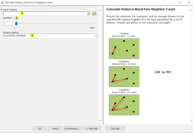
Returns the minimum, the maximum, and the average distance to the specified Nth nearest neighbor (N is an input parameter) for a set of features. Results are written as tool execution messages.
لعرض الحد الأدنى والحد الأقصى ومتوسط المسافة إلى أقرب الجار رقم N المحدد (N معلمة إدخال) لمجموعة من المعالم. تتم كتابة النتائج كرسائل تنفيذ الأداة.
1. Input Features أدخل المعالم
The feature class or layer used to calculate distance statistics.
فئة المعالم أو الطبقة المستخدمة لحساب إحصائيات المسافة.
2. Neighbors الجيران
The number of neighbors (N) to consider for each feature. This number should be any integer between one and the total number of features in the feature class. A list of distances between each feature and its Nth neighbor is compiled, and the maximum, minimum, and average distances are output to the Results window.
عدد الجيران (N) الذي يجب مراعاته لكل ميزة. يجب أن يكون هذا الرقم أي عدد صحيح بين واحد وإجمالي عدد المعالم في فئة المعالم. يتم تجميع قائمة بالمسافات بين كل معلم ومجاوره N ، ويتم إخراج المسافات القصوى والدنيا والمتوسطة إلى نافذة النتائج.
3. Distance Method طريقة المسافة
Specifies how distances are calculated from each feature to neighboring features.
· EUCLIDEAN_DISTANCE—The straight-line distance between two points (as the crow flies)
· MANHATTAN_DISTANCE—The distance between two points measured along axes at right angles (city block); calculated by summing the (absolute) difference between the x- and y-coordinates
يحدد كيفية حساب المسافات من كل معلم إلى المعالم المجاورة.
• EUCLIDEAN_DISTANCE - مسافة الخط المستقيم بين نقطتين (أثناء تحليق الغراب)
• MANHATTAN_DISTANCE — المسافة بين نقطتين مقاسة على طول المحاور بزوايا قائمة (كتلة المدينة) ؛ محسوبة بجمع الفرق (المطلق) بين إحداثيات x و y
Collect Events
أداة جمع الأحداث
How to use Collect Events Tool in Arc Toolbox ArcMap ArcGIS??
 |
| Collect Events Tool |
كيفية استخدام أداة جمع الأحداث ؟؟
Path to access the toolمسار الوصول الى الأداة
:
Collect Events Tool, Utilities Toolset, Spatial Statistics Tools Toolbox
Collect Events
Converts event data, such as crime or disease incidents, to weighted point data.
يحول بيانات الأحداث ، مثل حوادث الجريمة أو المرض ، إلى بيانات النقطة الموزونة.
1. Input Incident Features ادخل معالم الحادث
The features representing event or incident data.
المعالم التي تمثل بيانات الحدث أو الحادث.
2. Output Weighted Point Feature Class فئة ميزة نقطة مرجحة المخرجة
The output feature class to contain the weighted point data.
فئة معلم الإخراج التي تحتوي على بيانات النقطة الموزونة.
اليك صفحه ومجموعة على الفيس بوك لتعلم أكثر بما يخص نظم المعلومات الجغرافية (GIS) و برنامج ArcGIS Pro من خلال هذه الروابط:


تعليقات
إرسال تعليق