Convert Spatial Weights, Export Feature Attribute Tools
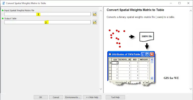
Convert Spatial Weights Matrix to Table
أداة تحويل مصفوفة
الأوزان المكانية إلى جدول
How to use Convert Spatial
Weights Matrix to Table Tool in Arc Toolbox ArcMap ArcGIS??Convert Spatial Weights Matrix to Table
كيفية استخدام أداة تحويل مصفوفة الأوزان المكانية إلى جدول ؟؟
Path to access the toolمسار الوصول الى الأداة
:
Convert Spatial Weights Matrix to
Table Tool, Utilities Toolset, Spatial
Statistics Tools Toolbox
Convert Spatial Weights Matrix to
Table
Converts a binary
spatial weights matrix file (.swm) to a table.
يحول ملف مصفوفة ثنائي الأوزان المكانية (.swm) إلى
جدول.
1.
Input Spatial Weights Matrix File إدخال
ملف مصفوفة الأوزان المكانية
The full pathname for
the spatial weights matrix file (.swm) you want to convert.
اسم المسار الكامل لملف مصفوفة الأوزان المكانية
(.swm) الذي تريد تحويله.
2.
Output Table الجدول المخرج
A full pathname to the
table you want to create.
اسم مسار كامل للجدول الذي تريد إنشاءه.
Export Feature Attribute to ASCII
أداة تصدير جدول
بيانات المعلم إلى أي سي أس إل إل
How to use Export Feature
Attribute to ASCII Tool in Arc Toolbox ArcMap ArcGIS??Export Feature Attribute to ASCII
كيفية استخدام أداة صدير جدول بيانات المعلم إلى أي سي أس إل إل ؟؟
Path to access the toolمسار الوصول الى الأداة
:
Export Feature Attribute to ASCII Tool, Utilities Toolset, Spatial
Statistics Tools Toolbox
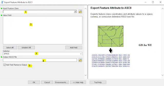
Export Feature Attribute to ASCII
Exports feature class
coordinates and attribute values to a space, comma, or semicolon-delimited
ASCII text file.
يصدر إحداثيات فئة المعالم وقيم السمة إلى ملف نصي
ASCII بمسافة أو فاصلة أو
فاصلة منقوطة.
1.
Input Feature Class ادخل فئة المعلم
The feature class from
which to export feature coordinates and attribute values.
فئة المعالم التي يتم من خلالها تصدير إحداثيات
المعالم وقيم السمة.
2.
Value Field قيمة الحقل
The field or fields in
the input feature class containing the values to export to an ASCII text file.
الحقل أو الحقول الموجودة في فئة معلم الإدخال
تحتوي على القيم المراد تصديرها إلى ملف نصي ASCII.
3.
Delimiter محدد
Specifies how feature
coordinates and attribute values will be separated in the output ASCII file.
·
SPACE—Feature coordinates and attribute values will be separated
by a space in the output.
·
COMMA—Feature coordinates and attribute values will be separated
by a comma in the output.
·
SEMI-COLON—Feature coordinates and attribute values will be separated
by a semicolon in the output.
يحدد كيفية فصل إحداثيات المعالم وقيم السمات في
ملف ASCII الناتج.
• SPACE -
سيتم فصل إحداثيات السمات وقيم السمة بمسافة في الإخراج.
• COMMA -
سيتم فصل إحداثيات الميزات وقيم السمات بفاصلة في الإخراج.
• SEMI-COLON - سيتم فصل إحداثيات السمات وقيم السمة بفاصلة منقوطة في الإخراج.
4. Output ASCII File ادخل الملف
The ASCII text file that
will contain the feature coordinate and attribute values.
الملف النصي ASCII الذي
سيحتوي على إحداثيات المعالم وقيم السمة.
5.
Add Field Names to Output أضف أسماء
الحقول إلى الإخراج
Specifies whether field
names should be included as the first line in the output text file.
·
Checked—Field names will be written to the output text file.
·
Unchecked—No field names will be written to the output text file.
يحدد ما إذا كان يجب تضمين أسماء الحقول كسطر أول
في ملف نص الإخراج.
• تم التحديد - ستتم
كتابة أسماء الحقول في الملف النصي الناتج.
• غير محدد - لن تتم
كتابة أسماء الحقول في الملف النصي الناتج.
اليك صفحه ومجموعة على الفيس بوك لتعلم أكثر بما يخص نظم المعلومات الجغرافية (GIS) و برنامج ArcGIS Pro من خلال هذه الروابط:


تعليقات
إرسال تعليق