Select by Dimension and Table to NetCDF Tools
Select by Dimension
أداة التحديد من
خلال الأبعاد
ArcMap ArcGIS
How to use Select by Dimension Tool in Arc Toolbox ArcMap ArcGIS??
كيفية استخدام أداة التحديد من خلال الأبعاد
؟؟
Path
to access the toolمسار الوصول الى الأداة
:
Select
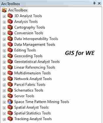
by Dimension Tool, Multidimension Tools Toolbox
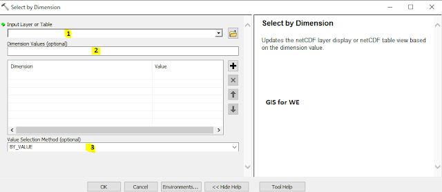
Select by Dimension
Updates the netCDF layer
display or netCDF table view based on the dimension value.
يحدّث عرض طبقة netCDF أو
عرض جدول netCDF بناءً على قيمة البعد.
1.
Input Layer or Table أدخل الطبقة او
الجدول
The input netCDF raster
layer, netCDF feature layer, netCDF table view, or mosaic layer. If the input
is a mosaic layer, it must be multidimensional.
طبقة المدخلات netCDF
النقطية أو طبقة معالم netCDF أو عرض جدول netCDF أو
طبقة الفسيفساء. إذا كان الإدخال عبارة عن طبقة فسيفساء ، فيجب أن تكون متعددة
الأبعاد.
2.
Dimension Values (optional) قيم
الأبعاد (اختياري)
A set of dimension-value
pairs used to specify a slice of a multidimensional variable.
·
Dimension—A netCDF dimension.
·
Value—A value of the dimension to specify a slice of a
multidimensional variable. A drop-down arrow will appear if the number of
available values is less than or equal to 200.
مجموعة من أزواج الأبعاد والقيمة المستخدمة لتحديد
شريحة من متغير متعدد الأبعاد.
• البعد - بعد netCDF.
• القيمة - قيمة البعد
لتحديد شريحة من متغير متعدد الأبعاد. سيظهر سهم منسدل إذا كان عدد القيم المتاحة
أقل من أو يساوي 200.
3.
Value Selection Method (optional) طريقة
تحديد القيمة (اختياري)
Specifies the dimension
value selection method.
·
BY_VALUE—The input value is matched with the actual dimension
value.
·
BY_INDEX—The input value is matched with the position or index of
a dimension value. The index is 0 based; that is, the position starts at 0.
يحدد طريقة اختيار قيمة البعد.
• BY_VALUE - تطابق قيمة الإدخال مع قيمة البعد الفعلية.
• BY_INDEX - تطابق قيمة الإدخال مع موضع أو فهرس قيمة البعد. الفهرس قائم
على 0 ؛ أي أن الموضع يبدأ من 0.
Table to NetCDF
أداة جدول الى نيت
سي دي أف
ArcMap ArcGIS
How to use Table to NetCDF Tool in Arc Toolbox ArcMap ArcGIS??
كيفية استخدام أداة جدول الى نيت سي دي أف
؟؟
Path
to access the toolمسار الوصول الى الأداة
:
Table to NetCDF Tool, Multidimension Tools Toolbox
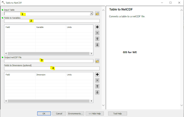
Table to NetCDF
Converts a table to a
netCDF file.
يحول الجدول إلى ملف netCDF.
1.
Input Table أدخل الجدول
The input table.
جدول الإدخال.
2.
Fields to Variables الحقول الى
متغيرات
The field or fields used
to create variables in the netCDF file.
·
Field—A field in the input feature attribute table.
·
Variable—The netCDF variable name.
·
Units—The units of the data represented by the field.
الحقل أو الحقول المستخدمة لإنشاء متغيرات في ملف netCDF.
• حقل - حقل في جدول سمة
الإدخال.
• متغير - اسم متغير netCDF.
• الوحدات - وحدات
البيانات التي يمثلها الحقل.
3.
Output netCDF File ملف النيت سي دي
أف المخرج
The output netCDF file.
The file name must have a .nc extension.
ملف الإخراج netCDF. يجب
أن يكون لاسم الملف ملحق. nc.
4.
Fields to Dimensions (optional) الحقول
إلى الأبعاد (اختياري)
The field or fields used
to create dimensions in the netCDF file.
·
Field—A field in the input table.
·
Dimension—The netCDF dimension name.
·
Units—The units of the data represented by the field.
الحقل أو الحقول المستخدمة لإنشاء أبعاد في ملف netCDF.
• حقل - حقل في جدول
الإدخال.
• البعد - اسم بُعد netCDF.
• الوحدات - وحدات البيانات التي يمثلها الحقل.
اليك صفحه ومجموعة على الفيس بوك لتعلم أكثر بما يخص نظم المعلومات الجغرافية (GIS) و برنامج ArcGIS Pro من خلال هذه الروابط:


تعليقات
إرسال تعليق